This is the most comprehensive Santa Cruz Island Backpacking Guide. It contains everything you need to know to do the ultimate backpack on Santa Cruz Island in the Channel Islands National Park.
The Channel Islands National Park consists of five islands located just off the coast of sunny California. On these islands, you will find loads of hiking, camping, kayaking, snorkeling, and other recreational activities.
The islands are well-protected, and the National Park Service does an excellent job of minimizing human impact. Due to the fragile ecosystem, if you plan on visiting this National Park, you’ll need to plan ahead.

IN THIS GUIDE, WE SHARE ALL THE LOGISTICS FOR PLANNING A BACKPACKING TRIP ON SANTA CRUZ ISLAND LOCATED 25 MILES OFF OF THE COAST OF CALIFORNIA.
You should practice good trail etiquette at all of our shared destinations and remember to Leave No Trace. That means packing out your garbage, being respectful of others on busy trails, and following the established rules.
(This post contains affiliate links. If you use these links to buy something we may earn a commission. Thanks!)

Getting To The Santa Cruz Islands
From Ventura Harbor, Island Packers offers regular boat ferries and cruises to Santa Cruz and the other islands in Channel Islands National Park.


The trip to Prisoners Harbor or Scorpion Anchorage on Santa Cruz Island takes slightly over an hour. Be aware that the boat ride can be cold and rough, so dress accordingly with layers. If you get seasick, consider taking preventive steps before the ride, such as purchasing anti-nausea bands or packing Dramamine. If you start to feel sick while on the boat, head to the back for fresh air and keep your eyes on the horizon.

You must check in at the Channel Islands office at least one hour prior to your departure to pick up your ticket. Before you put your bags on board they will ask you to remove any water containers and gas/fuel. These will be held in a separate, fire-safe container and collected once you get to the island. Be sure to mark your fuel canisters with your initials or name so it is easy to identify.
It’s a good idea to call Island Packers at (805) 642-1393 prior to your boat ride to ensure your trip has not been canceled due to rough seas.

Santa Cruz Island Map

Santa Cruz Island Weather
The best time to visit Santa Cruz is from September to November when the summer tourists have left and the beaches, hiking trails, and other attractions are less crowded.
The warmest month of the year in Santa Cruz is September, where the average temperature gets to around 23℃ (73℉), but temperatures can reach as high as 25℃ (78℉) on the hottest days in summer. The weather in the winter, especially around December, can reach a minimum of 6℃ (43℉).
Here is a link to check the Current Weather and forecast.
Camping Reservations
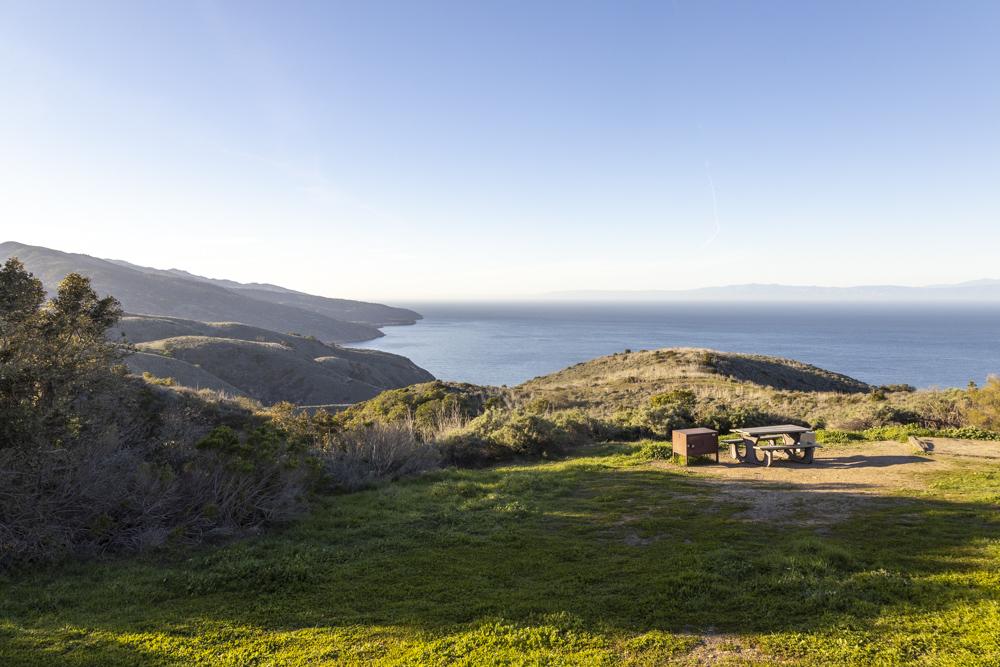
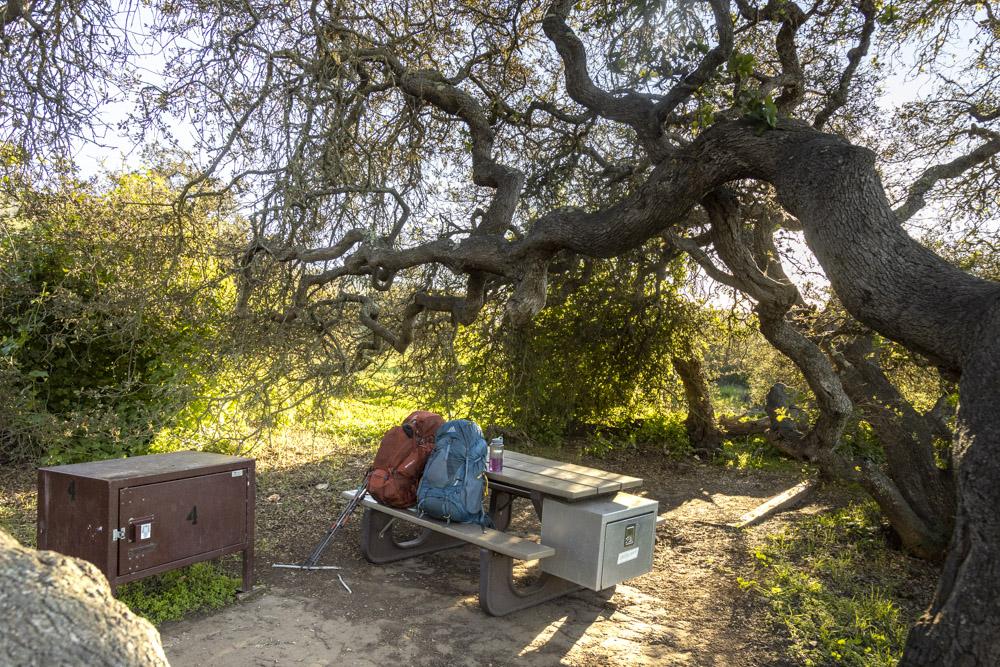
Del Norte Campground : To camp at the Del Norte Campground, you must have both a boat reservation and a campground reservation. The Del Norte campground, SCI is the smallest campground in the park. There are only four sites each with a four-person capacity for a maximum of 16 total campers at one time. Located 3.5 uphill miles from the pier where you disembark the boat. This is a “backcountry” campground. Rustic and charming with beautiful views of the island coast, this campground is frequented by backpackers and hearty hikers.
Picnic tables and small food storage boxes are in each site. NO fresh/potable water is available at this location and most years no streams or creeks flow to allow for water filtration by campers.


Most Scenic Campsite: Site 1 give you gorgeous views of the water but you are very exposed
Most Private Site: Site 4 gives you some privacy and shelter from the winds.
Scorpion Canyon Campground: To camp here, you must have both a boat reservation and a campground reservation. Scorpion Anchorage offers the most numerous and most-visited campsites in the Park. The campground area has shade in most sites provided by old-growth eucalyptus trees.
There are two campgrounds – Upper and Lower. Lower is closer to the harbor and therefore a bit more exposed to the elements and humidity. If you plan on doing more water activities, stay in Lower Scorpion Campground for quicker pier access. If you plan on doing more inland hiking, Upper Scorpion Campground is the spot for you.


The placement of the campground in Scorpion Canyon provides shelter from the prevailing NW winds. There are no trash cans for the public on the island, so you must pack out all trash when you leave.
You may reserve up to 7 consecutive nights.
Santa Cruz Island Backpacking Trail Map

Water Availability (IMPORTANT)
Drinkable water is VERY scarce on the island. Be prepared to carry extra water, especially in warmer weather. Potable water is ONLY available at the Scorpion Ranch campground on Santa Cruz Island.
Santa Cruz Island Backpacking Itinerary
- Day 1: Hike Prisoners Harbor to Del norte Campground | 4.8 miles
- Day 2: Hike Del Norte Campground to Scorpion Anchorage Campground | 9.5 miles
- Day 3: Optional Exploratory Hike (optional) | Smugglers Road, Scorpion Canyon, Potato Harbor | ~8 miles
- Day 4: Kayak Tour at Scorpion Anchorage | Hike to Scorpion Canyon Ferry | .5 miles
There are a few variations that you could do to this itinerary. We chose to designated Day 3 as a full exploratory day in order to really kick back and enjoy the island. This gave us enough time to explore all the parts we wanted to see. We also like to spice up our trips, so we allotted time on Day 4 to take a guided kayaking tour.
Trip Report
Day 1: Hike Prisoners Harbor to Del norte Campground (3.2 miles, 1182 elevation gain)
- Potable Water Availability: None available
- Best Campsite at Del Norte Campground: #1 (most scenic) | #4 (most private)
I would recommend getting the earliest ferry out of Ventura so that you can get to the island with plenty of time to explore and, if possible, do the Pelican Bay Hike. You will need to fill out a form and submit this to the rangers before doing the hike. Only passengers of Island Packers are permitted to hike on this land, so take advantage of this unique opportunity.
The Pelican Bay Hike is a 4-mile out-and-back trail that gives offers some insanely beautiful views and gives you access to the sandy shores at Tinker Harbor. Do not miss this hike if you are comfortable with tacking on 4 additional miles to your first day. You can leave your big packs in the fox boxes at Prisoners Harbor and just take a day pack with snacks and water.

If you do the entire Pelican Bay Hike, expect to spend about 3 hours exploring. Once you are back at Prisoners Harbor, grab a quick lunch or snack, pack it up, and head out to your first leg of the backpack.


Although the trail does snuggle up against the coastline to give you ocean views at every turn, the majority of the hike is along a road. And it is pretty dang steep. Once you get your boots dug into the actual trail, guess what, it gets even steeper! The trail drops you down into a valley and then straight up the other side a couple of times. However, the rolling hills, blue skies (hopefully) and water views make the hike fly by.

The turnoff for the campground is well marked at a Y intersection, and the sites are only a few hundred feet up the trail. While at camp, make sure to place all of your food, or anything scented inside the fox boxes. The Island foxes are definitely not shy and will start inspecting the new visitors as soon as you arrive. It is recommended to keep all of your gear, socks, bags off the ground and tabletop as these little dudes just may be curious enough to rustle through your goods to try to find some snackies.


Day 2: Hike Del Norte Campground to Lower Scorpion Campground (9.7 miles, 2322 elev gain)
- Potable Water Availability: Water available at both Upper and Lower Scorpion Campground
- Best Campsite at Lower Scorpion Campground: #3 (most private & best access)
Get an early start to give yourself plenty of time to enjoy the views. It is possible to add a side trip down to Chinese Harbor (adds 3.6 miles roundtrip). The average time to hike from Del Norte Campground to Lower Scorpion is about 5-6.5 hours, but trust me, you will want to stop to take some photos. Many, many, many photos.

It is pretty incredible how often and vastly the landscape changes along this trail. Some of the hike cuts its way between high grass valleys, over wide-open hilltops, down into deep, rocky valleys, and around some sketchy edges up to a spine that overlooks the west side of the island.


The turnoff for Chinese Harbor is about 2.3 miles from the Del Norte Campground. You should note that this will take you to an overlook of Chinese Harbor, and not down to the beach. The hike is 1.8 miles each way.
This hike really rakes a turn for the awesome the moment you link up with Montañon Trail at about the 5.2-mile mark. The massive peaks in the distance seem impassable, making you question where in the heck you are even headed. You can make out parts of the trail, but it seems to disappear around a very steep corner. And that’s because it does!


What started out as a relatively passive hike, gets gnarly with the quickness as you take a quick ascent up to Montañon Ridge. The terrain gets pretty chunky and narrow as it curves its way around a lower ridge, followed by an incredibly scenic 360-viewpoint on top of the ridgeline. Being that this junction is very close to the highest point on the island, you get massive views of the western coastline on one side and Scorpion Harbor on the other. On clear days, you can see Anacapa Island!

This is the part where someone (there’s always that guy) starts saying “It’s all down here from here.” But, for once, he won’t be lying. The next 4 miles wind their way down to Scorpion Harbor. There are two trails you could take to get to the campgrounds. We went for the slightly longer one that drops you into the valley, passing through Upper Scorpion Campground and then into Lower Scorpion. Just passed that is the harbor.
There is a fantastic short hike that will lead you to an overlook of the harbor. Here, you will get sweeping views of the giant kelp forest floating below and the massive rock formations in the distance: Scorpion Rock. This is a killer location to photograph sunset or sunrise.


Day 3: Optional Exploratory Hike | Smugglers Road, Scorpion Canyon, Potato Harbor | ~8 miles
There are many ways to spend the day hiking and exploring all the goods on this side of the island. We compiled an 8-mile loop that hits all of the hot spots. You will cover a couple of miles that you did on the way into Scorpion Canyon on Day 2. If you would like to spend more time along the amazing North Bluff Trail instead, do this shorter loop that starts from the Upper Scorpion Campground.


To do the full loop, start off by heading out of camp towards the harbor and turn right onto Smugglers Road. This will take you right up to the top of the cliffs and over to Scorpion Bluffs. The trail will then lead you back inland on the island, circling back around to the campgrounds.


From Upper Scorpion Campground, turn left onto Potato Harbor Road. This climbs its way up to intersect with the North Bluff Trail. Head west on the North Bluff Trail until you reach the most beautiful part of the island: Potato Harbor Overlook.

Day 4: Kayak Tour at Scorpion Anchorage | Hike to Scorpion Canyon Ferry | .5 miles
We scheduled our return ferry for 4 pm so that we could sleep in and enjoy a group breakfast. In the early afternoon, we headed out on a kickass guided kayak tour to see the island from the water!

The Adventure Sea Cave Kayaking experience was incredible! TBH, we tend to stay away from guided tours. We like the freedom to roam freely and get our own take on the experience. But, that’s not an option here because it is a protected preserve.


Now, I will be the first to admit – we were dead wrong! The $169 price tag was well worth it! We were shown a lot of really rad sea caves, paddled through tunnels, and got soaked by explosive blow spouts. Our guide kept us entertained and talked about the super interesting history of the island. We learned the names of the birds that live exclusively on the island and tasted kelp fresh from the ocean. Yes, that is correct. We ate kelp.
You can book your adventure in advance here – which is highly recommended during the busier seasons.
Cell Phone Reception
Don’t expect really any cell phone service on your Santa Cruz Island backpacking trip. The reception will be very sporadic and unreliable. It’s a good idea to turn off or put your phone on airplane mode. Otherwise, your phone will roam about looking for a signal, draining your battery. How else are you going to get those banger IG boomerangs?!
We found that the only place we reliably had any reception at all was on the pier at Scorpion Anchorage.
Santa Cruz Backpacking: What Gear Do You Need?
Make sure to Download our 3 Day Backpacking Checklist. By adding in a couple more meals, snacks and a little more clothing, you could easily adapt this to 4 days.

Below you will find a list of the gear that we took on this trip. It includes almost every piece that we had with us in our backpacks. This was the first time we used the Gregory Backpack Combo, and it worked out perfectly. I would argue that this combo may be the perfect backpacking duo for the adventurous couple.
His
- Backpack: Gregory Baltoro 75
- Tent: Nemo Hornet 2p
- Sleeping Bag: Nemo Kayu 15
- Sleeping Pad: Nemo Tensor Wide
- Shoes: Hoka One One Anacapa Mid GTX and Chacos
- Headlamp: Petzl Reactik
- Sunglasses: Rheos Coopers
- Hiking Poles: Black Diamond Trail Ergo
- Clothing: Marmot Knife Edge | Eddie Bauer Guide Pro Pant | Vuori Trail Shorts | Outdoor Research Echo Hoodie | Arcteryx Atom LT Hoody | Smartwool Performance Hike Light Socks
- Food Stuffs: Jetboil Zip | Fatty Meat Sticks | Ultima Electrolytes | Mountain House Meals | Starbucks VIA | Nalgene 32oz Water Bottle
- Camera Gear: Canon R, Canon 24-105 lens, GoPro Hero 9
Hers
- Backpack: Gregory Maven 55
- Sleeping Pad: Nemo Tensor Regular
- Sleeping Bag: Marmot Trestles 15
- Sleeping Bag Liner: Cocoon Silk Mummy
- Pillow: Klymit Pillow X
- Shoes: Hoka One One Tennine GTX
- Sunglasses: Rheos Wyecreeks
- Clothing: Marmot Knife Edge
- Food Stuffs: Wild Zora Paleo Meals | Wild Zora Snacks | Wild Zora Grain Free Hot Cereal | Four Sigmatic Mushroom Coffee Mix |
A note about Ticks
Ticks are present on the islands and can carry bacteria and viruses that can cause diseases in humans, including Lyme disease. Now, you see this sign oftentimes at trailheads and they advise you to check yourself. I never take it too seriously, but the ticks on this island are aggressive! Seriously, if you literally step a foot off the trail to snap a quick photo, there’s a good chance one of these suckers will get on you.
Periodically check yourself throughout the hike and again when you get to camp. They are harmless if you swat them off before they dig in. If they have latched on, make sure you know how to remove them safely and completely. The Clever Hiker wrote a fantastic article covering ticks that I suggest you check out.